


Imagery
Below is a collection of images to illustrate stories about National Highways' infilling and demolition of Historial Railways Estate structures. Media organisations are authorised to use these images as long as the specified credit is included within the relevant publication.
Click on the thumbnail image to download a high-res version.
Great Musgrave bridge
.jpg)
Great Musgrave bridge north side
The north side of Great Musgrave bridge following removal of the infill.
Credit: The HRE Group (1.68MB)
.jpg)
Great Musgrave bridge south side
The south side of Great Musgrave bridge following removal of the infill
Credit: The HRE Group (1.87MB)
.jpg)
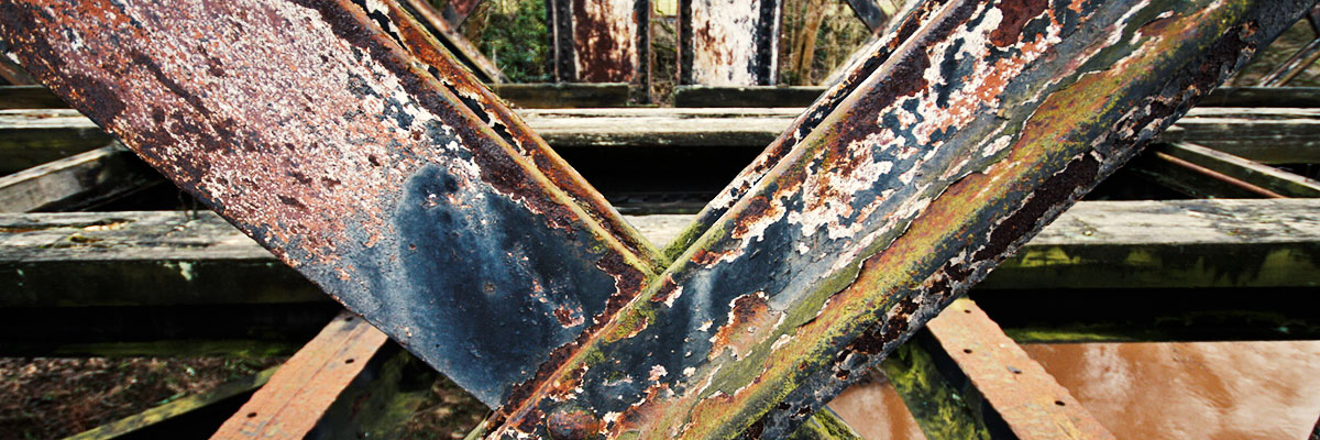
Great Musgrave bridge repair
A patch repair in the arch of Great Musgrave bridge carried out using a 'restoration mortar'. The coursing has not been maintained.
Credit: The HRE Group (2.05MB)
.jpg)
Great Musgrave bridge defect
A damaged stone block in the arch of Great Musgrave bridge.
Credit: The HRE Group (1.68MB)
.jpg)
Great Musgrave bridge infill removal
The north side of Great Musgrave bridge as work to remove the infill from around it reached its conclusion.
Credit: The HRE Group (2.19MB)
.jpg)
Great Musgrave bridge infill removal
Protection matting supports the cutting slope to the south-west of the bridge after removal of its stone and concrete infill.
Credit: The HRE Group (2.24MB)
.jpg)
Great Musgrave bridge infill removal
A view of Great Musgrave bridge's arch after localised repointing and repairs to the damage caused by removal of the concrete infill.
Credit: The HRE Group (1.7MB)
.jpg)
Great Musgrave bridge
The bridge at Great Musgrave comprises a masonry arch and is needed for a planned connection between the Eden Valley and Stainmore heritage railways.
Credit: The HRE Group (2.35MB)
.jpg)
Great Musgrave bridge infilling
Great Musgrave bridge was infilled in May and June 2021 without planning permission and in the complete absence of dialogue with the two railways who need access beneath it.
Credit: The HRE Group (2.58MB)
.jpg)
Great Musgrave bridge infilled
Great Musgrave bridge was infilled using hundreds of tonnes of aggregate and foamed concrete, create an environmental blight and loss of a useful legacy structure.
Credit: The HRE Group (2.32MB)
.jpg)
Great Musgrave bridge south
Concrete oozes from the arch on the south side of Great Musgrave bridge.
Credit: The HRE Group (2.08MB)
.jpg)
Great Musgrave bridge arch
Part of the infill on the bridge's north side was removed during preparatory works in June 2023.
Credit: The HRE Group (2.66MB)
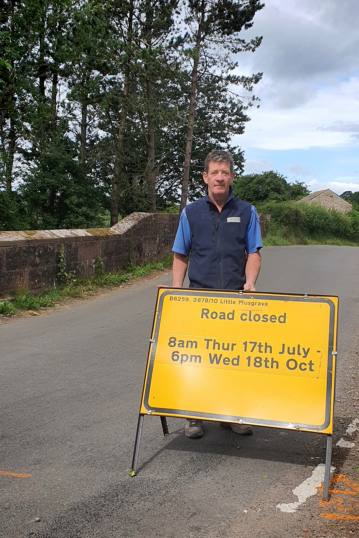
Great Musgrave bridge closure
Tim Wells, chair of Musgrave Parish Council, with a road closure sign on the bridge.
(2.23MB)
Congham bridge
.jpg)
Congham bridge archive
The infilled bridge carrying St Andrew's Lane at Congham was rebuilt in 1926 and was a rare surviving example of an early modular reinforced concrete structure designed by pioneering engineer William Marriott.
Credit: M&GN Trust (388kB)
.jpg)
Congham bridge aerial
The former King's Lynn-Fakenham railway - which used to pass under the bridge - is now earmarked as the route of a new greenway, although it's not currently clear how much of the former trackbed will be used.
Credit: The HRE Group (2.25MB)
.jpg)
Congham bridge infilled
Congham bridge was infilled with hundreds of tonnes of aggregate and concrete under permitted development rights that only apply in emergency situations.
Credit: The HRE Group (2.04MB)
.jpg)
Congham bridge
Congham bridge was composed of concrete bricks, blockwork and seven concrete-encased girders.
Credit: Norfolk's Disused Railways (2.13MB)
.jpg)
Congham road
Looking west over Congham bridge along St Andrew's Lane - a lightly-trafficked road with overhanging trees.
Credit: The HRE Group (2.39MB)
.jpg)
Congham bridge public inquiry
A public inquiry into National Highways' infilling of Congham bridge was held in King's Lynn in May 2024.
Credit: The HRE Group (1.03MB)
Rudgate bridge
Rudgate bridge archive
An archive photograph showing a train passing beneath Rudgate bridge in 1957.
Credit: The Transport Treasury Ltd (MM292) (925kB)
.jpg)
Rudgate bridge infilled
Hundreds of tonnes of aggregate and concrete were used to bury Rudgate bridge in March and April 2021.
Credit: The HRE Group (1.75MB)
.jpg)
Rudgate bridge aerial
A view of the bridge, looking down the old railway towards Tadcaster.
Credit: The HRE Group (1.49MB)
.jpg)
Rudgate bridge sign
The structure carried a narrow lane which is prohibited to vehicles of more than 3 tonnes unladen..
Credit: The HRE Group (1.49MB)
.jpg)
Rudgate bridge
Rudgate bridge was built in the 1840s and spanned a railway which has been partly converted into a cycle path.
Credit: Robert Matley (1.51MB)
.jpg)
Rudgate greenway
Rudgate bridge is located around 340m from the existing end of a greenway heading north-west to Wetherby, with longstanding plans to extend it south-eastwards into Tadcaster.
Credit: The HRE Group (2.44MB)
Barcombe bridge
.jpg)
Barcombe protest
A community campaign against National Highways’ proposed plan for the bridge has been launched.
Credit: The HRE Group (2.09MB)
.jpg)
Barcombe community
Locals gather beneath the bridge to discuss their strategy to combat the infill scheme.
Credit: The HRE Group (2.14MB)
.jpg)
Barcombe gathering
Locals gather beneath the bridge to discuss their strategy to combat the infill scheme.
Credit: The HRE Group (1.94MB)
.jpg)
Barcombe campaigner
Hazel Fell Rayner, the local campaign organiser, signs the community's letter against the infilling scheme.
Credit: The HRE Group (1.16MB)
.jpg)
Barcombe defects
Cracks developed in three of the bridge’s wing walls at some time prior to 1994.
Credit: The HRE Group (1.76MB)
.jpg)
Barcombe parapets
The bridge’s parapets are cracked at all four corners of the span.
Credit: The HRE Group (1.79MB)
.jpg)
Barcombe cyclists
Two cyclists pass over the bridge which has a weight restriction of 20 tonnes.
Credit: The HRE Group (1.84MB)
Toller Porcorum bridge
.jpg)
Toller Porcorum bridge
In October 2021, National Highways' contractor accessed property and felled trees without consent from the three affected landowners.
Credit: Richard Sims (1.04MB)
.jpg)
Toller Porcorum flood
The shredded timber from the tree felling caused the road drains to block, resulting in deep flooding.
Credit: Nigel Ewens (1.77MB)
.jpg)
Toller Porcorum trees
Trees were cut down on both sides of the bridge.
Credit: Richard Sims (1.02MB)
Stoke Road bridge
.jpg)
Stoke Road bridge route
An aerial view across Stoke Road bridge, showing the old railway which is proposed for repurposing as a walking and cycling route.
Credit: The HRE Group (1.58MB)
.jpg)
Stoke Road bridge deck
The bridge carries a little-used country lane over the former Mid-Hants Railway which opened in 1865.
Credit: The HRE Group (1.85MB)
.jpg)
Stoke Road bridge
Uncontrolled ivy growth has caused localised mortar loss to the bridge’s parapets, spandrels and arch ring face, but these defects are minor.
Credit: The HRE Group (2.28MB)
Horspath bridge demolition
.jpg)
Horspath protest
On 24 February 2021, villagers gather on a bridge at Horspath to protest against National Highways' intended demolition of the structure that is valued locally as a traffic-calming measure and wildlife corridor.
Credit: Helen Morgan (264kB)
.jpg)
Horspath protest aerial
On 24 February 2021, villagers gather on a bridge at Horspath to protest against National Highways' intended demolition of the structure that is valued locally as a traffic-calming measure and wildlife corridor.
Credit: Simon Logan (2.53MB)
.jpg)
Horspath bridge
The structure is valued locally as a traffic-calming measure and wildlife corridor.
Credit: The HRE Group (2.23MB)
Notable bridges under threat
.jpg)
Alnwick bridge
One of two bridges intended for infilling on the route of the proposed Alnwick Greenway which would head out of town into the fabulous Northumberland countryside.
Credit: The HRE Group (2.55MB)
.jpg)
Brunel bridge
Isambard Kingdom Brunel engineered this bridge for the Cornwall Railway in the 1860s, but National Highways told Cornwall Council that it needs to be infilled "to prevent an emergency arising". It carries a little-used farm track and is 220m for the nearest public right of way.
Credit: The HRE Group (2.28MB)
.jpg)
Dukes Avenue bridge
At Alexandra Palace, National Highways intends to demolish this brick structure which forms part of a conservation area.
Credit: Matt Buck (2.09MB)
.jpg)
Fakenham bridge
The ambitious establishment of a Norfolk Orbital Railway would be prejudiced by National Highways' proposed infilling scheme of this bridge near Fakenham.
Credit: Norfolk Orbital Railway (2.07MB)
.jpg)
Hackney Bottom bridge
A future phase of the National Highways-funded Newbury-Didcot Railway Path will pass beneath this bridge near Hackney Bottom, but only if another part of National Highways doesn't infill it first.
Credit: The HRE Group (2.06MB)
.jpg)
Kinnersley bridge
One of four at-risk bridges spanning the route of the proposed Hereford-Hay Greenway. Two were the subject of planning applications for infilling, but Herefordshire Council rejected them.
Credit: The HRE Group (2.22MB)
.jpg)
Lochanhead bridge
The Dumfries-Stranraer railway is being considered for reopening as part of the South West Scotland Transport Study, but National Highways plans to infill this bridge, blocking the route and weakening the business case.
Credit: The HRE Group (2.33MB)
.jpg)
Pont Llanio bridge
Pont Llanio bridge spans the former Carmarthen-Aberystwyth railway which would form part of a strategic north-south link through west Wales. A campaign group wants it to be reopened for social purposes and the Welsh Government has conducted a study.
Credit: Bob Morgan (2.0MB)
.jpg)
Pugeston bridge
Protected by a Grade C listing due to its unusual construction form, this bridge at Pugeston in Angus could span an extension of the Caledonian Railway if National Highways is prevented from infilling it.
Credit: Simon Douglas (1.9MB)
.jpg)
Staward Station bridge
Staward Station is Northumberland has been delightfully restored, but holidaymakers staying in the former waiting room could soon be looking out at concrete infill if National Highways gets its way.
Credit: The HRE Group (1.43MB)
.jpg)
Tilekilns bridge
This bridge at Kirtlebridge - just over the Scottish border - is used as a wildlife corridor and forms the only access route onto three acres of a farmer's property. But despite a Minister's assurance that National Highways would endeavour to retain access beneath any bridge where an interest is identified, the structure will be infilled.
Credit: The HRE Group (1.68MB)
.jpg)
Troutbeck bridge
Contractor AMCO-Giffen progresses the partial infilling of a bridge on the former Penrith-Keswick branch in the Lake District which is the focus of a longstanding reopening campaign. The new arched opening is not big enough to accommodate a train.
Credit: The HRE Group (1.87MB)
.jpg)
Uplawmoor bridge
Three unusual concrete bridges are needed for the Neilston-Uplawmoor Community Link in East Renfrewshire which is currently at the detailed design stage. National Highways would scupper the project if it goes ahead with its threat to infill them.
Credit: Ross Cowan (2.07MB)
Converted bridges
.jpg)
Heckmondwike bridges
A series of impressive bridges span a cutting on a section of cycle path at Heckmondwike, West Yorkshire.
Credit: The HRE Group (1.64MB)
.jpg)
Little Petherick bridge
A bridge carries cyclists over Little Petherick Creek near Padstow, Cornwall, on a cycle trail.
Credit: The HRE Group (1.37MB)
.jpg)
Keswick bridge
Walkers and cyclists pass beneath a masonry bridge on a section of the Keswick-Threlkeld railway path in the Lake District.
Credit: The HRE Group (1.94MB)
.jpg)
New Forest bridge
Walkers and cyclists pass beneath a masonry bridge on a section of disused railway in the New Forest.
Credit: The HRE Group (2.16MB)
About Us
The HRE Group is an alliance of walking, cycling and heritage campaigners, engineers and greenway developers who regard the Historical Railways Estate’s structures to be strategically valuable in the context of building a better future.
Last updated 21 October 2025
© 2025 The HRE Group